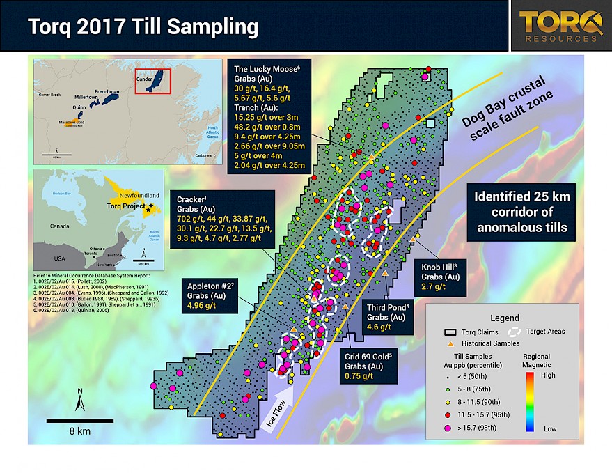
VANCOUVER, British Columbia - September 21, 2017 - Torq Resources Inc. (TSX-V: TORQ; OTCQX: TRBMF), “Torq” or the “Company”) is pleased to announce the results from the regional till sampling program on its Gander Gold Project located in central Newfoundland, Canada. The program was designed to identify centers of gold mineralization beneath till cover and has successfully identified 6 gold-in-till anomalies over a 25 km long structural trend. These anomalies represent primary targets for future exploration and drilling.
Torq’s strategy is to rapidly advance these targets to drill-ready status through an in-fill till sampling program planned for the fall, followed by trenching and ground geophysics.
Torq CEO, Michael Kosowan commented, “This is an excellent start to our goal of making a new major gold discovery in Newfoundland. The length of this trend is significant, with encouraging signs of gold endowment in the area.”
Mr. Kosowan further stated, “The Company is well positioned with $17 million in the treasury to pursue new discoveries in Newfoundland and make additional acquisitions in an effort to build a world class gold exploration portfolio.”
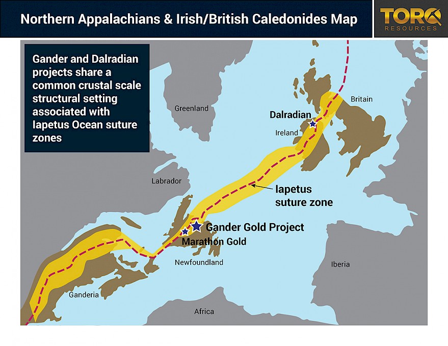
The program screened a 50 km by 15 km area along a crustal scale fault zone considered by Torq to be highly prospective for gold mineralization. A total of 1,749 samples were collected across the Gander Gold Project identifying six multi-kilometer long targets that cluster within a 25 km by 5 km corridor (Figure 1). The Company considers this geologic setting to be similar to Dalradian’s high-grade gold deposit in Northern Ireland. The Dog Bay Fault zone, which is found in Newfoundland’s Northern Appalachians and runs through the Gander Gold Project, is analogous to the tectonic and crustal scale settings found in the Irish/British Caledonides Mountains (Figure 2). Historical data from the Gander Gold Project demonstrates the high-grade gold potential of the region with several rock and trench samples above 10 g/t gold from both the Cracker and Lucky Moose prospects (See Table 1).
Table 1 - Historic grab and trench samples from selected prospects within the Gander Gold Project:
| Prospect | Sample Type | Au (g/t) |
|---|---|---|
| Cracker1 | Grabs | 702, 44, 33.87, 30.1, 22.7, 13.5, 9.3, 4.7, 2.77 |
| Appleton #22 | Grabs | 4.96 |
| Knob Hill3 | Grabs | 2.7 |
| Third Pond4 | Grabs | 4.6 |
| Grid 69 Gold5 | Grabs | 0.75 |
| The Lucky Moose6 | Grabs | 30, 16.4, 5.67, 5.6 |
| Trench | 15.25 g/t over 3m | |
| 48.2 g/t over 0.8m | ||
| 9.4 g/t over 4.25m | ||
| 2.66 g/t over 9.05m | ||
| 5 g/t over 4m | ||
| 2.04 g/t over 4.25m |
Refer to Mineral Occurrence Database System Report:
1. 002E/02/Au 015, (Pollett, 2002)
2. 002E/02/Au 014, (Lush, 2000), (MacPherson, 1991)
3. 002E/02/Au 004, (Evans, 1996), (Sheppard and Gallon, 1992)
4. 002E/02/Au 003, (Butler, 1988, 1989), (Sheppard, 1993b)
5. 002E/02/Au 010, (Gallon, 1991), Sheppard et al., 1991)
6. 002E/02/Au 018, (Quinlan, 2006)
Michael Henrichsen, P.Geo, and advisor to Torq, is the Qualified Person who assumes responsibility for the technical disclosures in this press release.
On Behalf of the Board,
Michael Kosowan
President and CEO
For further information on Torq Resources, please contact Jay Adelaar, Manager of Investor Relations at (778) 729-0500 or [email protected].
About Torq Resources:
Torq Resources is a junior exploration company with the goal of establishing a tier-one mineral portfolio. The Company’s management team has raised over $500M and monetized successes in three previous exploration companies. Its initial asset is a 120,000 hectare land package in Newfoundland, Canada, an emerging gold jurisdiction. Torq is continually reviewing and acquiring new precious metals targets on the path to discovery.
Forward Looking Information
This release includes certain statements that may be deemed “forward-looking statements”. Forward-looking information is information that includes implied future performance and/or forecast information including information relating to, or associated with, exploration and or development of mineral properties. These statements or graphical information involve known and unknown risks, uncertainties and other factors which may cause actual results, performance or achievements of the Company to be materially different (either positively or negatively) from any future results, performance or achievements expressed or implied by such forward-looking statements.
Neither the TSX Venture Exchange nor its Regulation Services Provider (as that term is defined in the policies of the TSX Venture Exchange) accepts responsibility for the adequacy or accuracy of this release.
Gander Till Sampling QA/QC Disclosure
Till samples (3 to 5 kg each) are sent to ALS Lab in Vancouver, BC for preparation and analysis. All samples are analyzed using Ultra-Trace Au by Cyanide Extraction and ICP-MS finish method (Au-CN44) and ultra-trace multi-element aqua regia digest ICP-AES/ICP-MS method (ME-MS41L). QA/QC programs using internal standard samples, field and lab duplicates, re-assays, and blanks indicate good accuracy and precision in a large majority of standards assayed.
Historic Grab and Trench Samples
The historic grab and trench samples were taken from Mineral Assessment Reports filed with Department of Nature Resources, Newfoundland. Grab samples are a non-representative sampling technique and may not be representative of the mineralization present on the project. Further, Torq has not conducted any due diligence on whether appropriate QA/QC protocols were followed in the collection of these samples, nor can it confirm their accuracy or repeatability.
Figure 1: Highlights 6 well defined till anomalies within a 25 km long corridor situated along the Dog Bay fault zone. These anomalies represent target areas that Torq will advance towards drill stage with a program of in-fill till sampling, ground geophysics and trenching slated to begin in early October.

Figure 2: Illustrates the common tectonic setting of the Northern Appalachians and Irish/British Caledonides Mountains with the closing of the Iapetus Ocean as outlined by the red dashes and yellow polygon.


